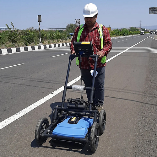
About Ground Penetrating Radar Survey Services
Experience phenomenal savings and procure the finest Ground Penetrating Radar (GPR) Survey Services from India's leading distributor and supplier. Utilizing trending GPR technologies operating between 200 MHz and 900 MHz, our high-precision surveys delve up to 10 meters, delivering unbeatable accuracy in mapping underground utilities. Our qualified geophysical engineers expertly handle data in both 2D and 3D formats, with reports generated in just 2-5 days. Tailored to your specifications, our solutions accommodate diverse soil types-clay, sand, gravel, asphalt, or concrete. Unrivaled onsite support and advanced software interpretation ensure maximum value for all your utility detection needs.
Competitive Advantages and Applications of GPR Surveys
Ground Penetrating Radar Survey Services provide exceptional value by combining advanced technology with the expertise of qualified geophysical engineers. Competitive advantages include rapid reporting (within 2-5 days), highly customizable surveys, and accurate 2D and 3D mapping across various soil types. The application media ranges from clay and sand to asphalt and concrete surfaces, making GPR suitable for underground utility detection across multiple industries. Easy-to-use onsite support and clear report formats ensure a seamless procurement and usage experience.
Certifications, Export Markets, and Sample Policy
Our Ground Penetrating Radar Survey Services are certified under the highest industry standards, ensuring precise and reliable results. We serve major export markets, offering a competitive rate with a minimal drop-off period for sample provision. Efficient transportation ensures rapid service across all locations in India. Our flexible sample policy is tailored to client requirements, emphasizing transparency and client satisfaction alongside quick delivery and attentive after-sales support.
FAQ's of Ground Penetrating Radar Survey Services:
Q: How does the Ground Penetrating Radar (GPR) technology detect underground utilities?
A: GPR technology emits high-frequency radio waves into the ground, which reflect off subsurface structures. These reflections are recorded and analyzed to create accurate 2D and 3D maps of underground utilities and features.
Q: What is the process for scheduling and executing a GPR Survey?
A: After contacting our team and specifying your requirements, our engineers assess your site, select appropriate GPR frequencies, and conduct a field survey. Data is processed using advanced software, and detailed reports are delivered in 2-5 days.
Q: When can I expect to receive the survey report after the site visit?
A: Reports are typically completed and delivered within 2 to 5 days of the field survey, depending on the project's complexity and specific site conditions.
Q: Where in India do you provide Ground Penetrating Radar Survey Services?
A: We offer our GPR Survey Services across all locations in India, ensuring comprehensive geographic coverage for both urban and remote areas.
Q: What are the benefits of using GPR for underground utility detection?
A: The benefits include high precision, minimal site disturbance, rapid reporting, the ability to map a variety of soil types, and customizable solutions to suit specific client needs.


 Send Inquiry
 Send SMS